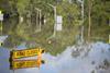
Over 30,000 people have been impaced as heavy rain and flooding continues to impact New South Wales
Over 30,000 residents of Sydney and its surrounding area were told to evacuate or prepare for evacuation as Australia’s largest city faces its second night of flooding, reports Associated Press.
“We currently, across New South Wales, have 64 evacuation warnings in place and 71 evacuation orders,” Dominic Perrottet, the NSW premier, said at a news conference. “That is impacting 32,000 people across New South Wales.”
Severe flooding is occurring along the Hawkesbury and Nepean rivers at Menangle, Wallacia and North Richmond with further flooding expected at Windsor and Lower Portland and Wiseman Ferry on Tuesday.
“The latest information we have is that there’s a very good chance that the flooding will be worse than any of the other three floods that those areas had in the last 18 months,” Emergency Management Minister Murray Watt said.
Severe weather warnings for damaging winds and hazardous surf are current for New South Wales and there remains the risk of flash flooding and landslips.
East Coast flood claims hit $5 billion
It comes after insurance claims for damage sustained during the February and March East Coast floods creep towards $5 billion, making the event the most costly flood event in Australia’s history.
Only Cyclone Tracy (1974) and the Sydney hailstorm (1999) caused more insured losses, according to the Insurance Council of Australia (ICA).
The East Coast Low is expected to weaken along with easing rainfall, but the risk of major flooding remains across parts of New South Wales, according to Australia’s Bureau of Meteorology.
With significant rainfall totals over many catchments in the past three days, some areas are expected to approach or exceed flood levels of recent events in March 2021, March 2022 and April 2022.
Some were hit by as much as 350mm of rainfall since Saturday, a volume that is almost half of Sydney’s annual average.
Warnings of further floods come Spring
Climate change is widely believed to be a contributing factor to the frequent severe weather events, according to the the Climate Council.
The Bureau of Meteorology has declared La Niña over, for now, however warns there is around a 50% chance it could return by spring.
“La Niña events can be damaging and costly for many Australian communities due to the greater risk of flooding,” said Dr Simon Bradshaw, the Climate Council’s director of research.
”A third consecutive La Niña could mean continued above average rainfall on an already saturated east coast. The risk of extreme rainfall and flooding is also increasing with climate change.”
“The new Labor Government must take steps now to get ahead of another potential summer of increased flood risk for these communities. We don’t want to see another situation where communities are left to their own devices.”
“Australia is under-prepared. Only a very small fraction of disaster spending is committed to preparedness and resilience building.
“We would expect to see a big shift in this ratio to see a much bigger focus on preparedness given the escalating risk of climate-fuelled disasters.”
Climate Councillor and leader of the Emergency Leaders for Climate Action (ELCA) group, Greg Mullins, added: “With catchments saturated and dams at capacity, another La Niña means we must prepare for more devastating floods.”
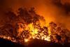
”It’s also a double-edged sword – when the rains eventually stop the prolific growth will inevitably fuel large grass fires across the interior, then bushfires as coastal forests dry out.”
”Unprecedented climate-driven weather means unprecedented demands on our already stretched emergency services.”


No comments yet