Satellites tracking natural catastrophes from space are an important source of data for innovative re/insurers
Russia’s invasion of Ukraine has opened the world’s eyes to the power of satellites with images of tanks and rockets giving viewers a vivid insight into the harsh realities of war.
As satellites become cheaper and more accessible, data and images from outer space are being used across a host of different industries. And they are set to be a “game-changer” for the re/insurance market.
With thousands of satellites sent into orbit each year, costing as little as £10,000 a time, companies are using earth observation data to their advantage.
Applications for re/insurers
In the re/insurance industry, satellite images are being used to track natural catastrophe events, provide verification for losses and claims, and manage ongoing insurance coverage among other applications.
Earth observation data is a new frontier for insurers, reinsurers and brokers as they look to narrow protection gaps and maximise coverage.
Patrick Devine, general counsel and head of regulation at space technology company Skytek, says satellites have become easier and cheaper to launch in the past decade.
“They are smaller, much more compact, and cheaper, bringing launch costs down,” he explains. “Skytek has the capability to task and acquire data from dozens of satellites,” he adds.
The technology arrives as the protection gap between economic and insured losses continues to widen, including in mature insurance markets.
Indemnity products can often be inadequate for certain risks, such as catastrophe perils, prompting the need for urgent further innovation in the insurance market.
It is hoped that earth observation data from satellites, drones, weather gages and other sensors, and the analysis of this data, will help address the information gap for insurers and reinsurers, and subsequently narrow the protection gap, leading to new insurance products and services.
As floods unfold
Helsinki-based satellite company ICEYE, for instance, collaborates with major insurance industry players including Swiss Re, Descartes, Fermat Capital and Tokio Marine to track flood events in near real-time using its satellite radar technology.
With the ability to see through clouds and at night the data offers near real-time insights into how losses are unfolding and impacting their portfolios.
And it can be used to structure parametric solutions for what has been historically a highly complex, dynamic and underinsured hazard.
“Flood water is a hazard that can cover wide geographic areas while also having very severe localised impacts,” explains Stephen Lathrope, global head of insurance at ICEYE. ”That combination of the need to scan very wide areas and zoom in on local impact is a perfect fit with our granular, yet expansive, earth observation data.”
Brokers are predicted to use space data to their advantage, building more accurate pictures of risk for their clients and using that information to deliver a value-add for corporate clients.
The future for parametrics
Oriol Gaspa Rebull head of reinsurance Solutions Analytics at Aon Japan, says the firm uses earth observation data to “set up some strategic partnerships to be able to support clients in the development of parametric products”.
“As technology evolves and measurements become more accurate, earth observations will become more relevant for the development of more reliable nat cat products,” Rebull adds.
While the emergence of earth observation data means information is readily available for insurers and brokers, widespread adoption is set to be a longer-term trend.
According to Devine, satellites can also track emissions from space, including methane emissions from farms, as the gas emits a chemical signal.
In the future, such information could be used to help companies keep track of and reduce their environmental footprints.
Speeding up claims; mitigating risk
Earth observation data is already having a big impact around claims.
Devine explains: “In the case of, say, property damage, ordinarily, loss adjusters would need to go in to check that out — but they are turning up after the event. With satellite data, you can actually go back and see if you can get a picture of that property around the time the event actually occurred and assess the value of the damage.”
Earth observation data is set be a valuable tool in validating parametric insurance claims, while it will also help to verify indemnity insurance coverage during natural catastrophes.
Devine believes it will also be useful for “monitoring risks”.
“Often, an underwriting file can just sit there for the year. But the availability of space data allows insurers and brokers to monitor the risk before you write it or renew it,” he says.
“An insurer could monitor a location over time and look for new risks. They could also make recommendations to reduce risk, based on the images, such as cutting back a forest to create a fire break. These kinds of interventions are a lot cheaper and quicker from space than sending people to California to do a site survey.”
He thinks space data will enable insurers to mitigate risks in their underwriting, a particularly useful tool as natural disaster events become more common due to climate change.
The wealth of earth observation data could help make insurance pricing more bespoke as insurers gain greater visibility over risk exposures.
“The historical data that we relied on around climate risks is now much less relevant,” says Devine. “There is more flooding, greater heat. It is becoming much more difficult to price.”
First movers
Insurance giants around the world are developing big data and satellite capabilities to build the next generation of products. Axa is among the large insurance groups to have embraced space data. Jaya Oswal, APAC project manager at Axa Climate, says the insurer is “reinventing insurance through transition and satellite by design”.
It has developed a product to insure rapeseed production in Europe with the help of satellite imagery, delivering insurance to growers that would have previously been unavailable.
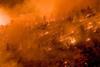
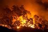
“We can also use earth observation to evaluate the damage done by wildfire,” Oswal adds. “We use satellite imagery to compare vegetation before and after a wildfire event and see the area impacted and the burn severity.
“We evaluate the risk by measuring the ground temperature, the dryness of the vegetation, the type of the vegetation, etc to see if an area is riskier than another.”
She is confident that the use of satellite data will help insurers, reinsurers, and their clients.
“With the maturity of data coming from independent, reputable organisations, it will allow insurers to structure innovative parametric covers. For clients, it will bring higher transparency and objectivity to the cover they are buying.”
Oswal believes it will be a vital tool as business and society adapts to the threat of climate change.
“Given that climatic and weather hazards today are one of the most important risks for mankind and businesses, we strongly believe that earth observation data will be a fundamental requirement to manage these hazards.
“We are already experiencing improvement in the maturity of insurance companies using earth observation data in creating extremely meaningful and innovative solutions for clients.”
No silver bullet
While earth observation data will help to close the protection gap, it is not a silver bullet.
“Earth observation data cannot help to fulfil the gap on its own,” says Oswal. “The problem is also the financial capacity of public and private actors. Premium subsidies, in particular for developing countries, are a way to help and close this protection gap.
“A strong focus on converting this observation data into effective risk transfer solutions, backed by large financial institutions and governments, will ensure that there is enough capital to bridge this gap.”
Devine, meanwhile, is convinced that satellites will soon be a vital tool across the industry.
“It doesn’t take too long for something to become a must-have,” he says. “While it is not required for every set of circumstances, it can be very helpful for pre-underwriting, monitoring on-risks during a policy year, and resolving disputes over claims and coverage. I believe space data will move from marginal to mainstream pretty quickly.”


No comments yet