


Rafal Modrzewski, CEO and co-founder of ICEYE, explains how advances in data are opening up new industry possibilities
How are advances in satellite technology helping to revolutionise how the insurance industry tackles disasters?
Satellite technology has evolved at an incredible rate over the last five to ten years. Satellite capabilities have expanded considerably greatly extending the range of applications, while at the same time the speed and cost of manufacture have reduced, enabling us to launch and maintain much larger constellations that orbit the earth on a much more frequent basis.
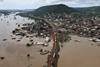
Another critical advance has been the development of synthetic aperture radar or SAR. What SAR enables us to do is to view changes on the earth’s surface in any conditions – through cloud, smoke, dust, or rain, and at night.
This overcomes many of the limitations of optical imagery and allows companies to monitor in high resolution developments on the ground such as flood, wildfire, hurricanes, or storm surge.
At ICEYE, we currently operate the world’s largest constellation of SAR-enabled satellites which are orbiting the earth multiple times each day. What this means is that the insurance industry can now monitor disasters in near real-time at a level of detail that simply was not possible before.
How is that data being used by insurers to manage catastrophe events more effectively?
A major stumbling block in the use of satellite technology has been the ability to convert the data into actionable insight. For that, you need to be able to combine the satellite imagery with a broader information set to create a more detailed loss picture that insurers can then map to their portfolio data.
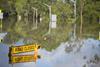
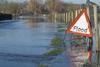
In the case of flood, for example, our meteorology team is constantly monitoring weather patterns to spot potential floods. Once we are tracking such an event, we will take images of the terrain expected to flood and then will image the event in near-real time as the flood develops.
By combining this data with other information sources, such as terrain data, elevation and hydrological models, and river gauges, via our AI capabilities we can generate both flood extent data as well as depth at the individual building level.
Insurers and MGAs can receive that flood information directly into their existing geospatial analysis tools to map to their property data to understand immediately the impact of the loss.
Or they can upload their property data to our ICEYE Insights platform via an API, and instantly visualise and analyse a flood event’s impact on their insurance customers with the latest event data.
How are insurers able to use this data to improve their ability to manage flood losses?
Once insurers have this granular flood extent and depth data, they can carry out multiple activities almost instantly. These range from managing the customer experience by proactively contacting those in the flood zone and triaging claims much more effectively, through to allocating resources to the most affected areas and managing reserves based on accurate loss data.
The aim is to make the data as readily usable as possible so that during that intense period of activity in the run-up to, during and in the aftermath of an event, the insurer is placed in a much stronger position to make those time-critical decisions that can significantly affect the outcome for both policyholder and insurer.
What this data also does is expand insurance potential – not just in relation to indemnity cover, but also for parametric solutions.
The market recognises the need for parametric insurance, particularly as the protection gap continues to widen.
Such risk transfer structures offer a much faster and more efficient way to pay claims, but a lack of granular, consistent, reliable data has to date limited their use.
ICEYE’s data can now be used as the basis for parametric triggers, showing quickly and accurately whether a structure has been triggered by an event, whether that is based on flood inundation levels or the number of assets affected in a location.
Recently, we have been involved in the development of a flood risk transfer solution in Ghana with a parametric insurance structure at its core. Involving multiple parties, including the Ghana Ministry of Finance, the United Nations Development Programme, and the Insurance Development Forum, the initiative is designed to enhance flood response capabilities in the Greater Accra Region, which is particularly exposed to such events.
We believe that the applications for ICEYE data are extensive. While we have now developed a robust flood solution, we are conducting comprehensive research into the development of solutions for other perils including wildfire, windstorm, and hail. The key for us is to work in tandem with the insurance industry and the public sector to maximise our data potential and truly deliver on what is possible.
GR Main Edition 2022: Disrupting the Oligopoly

As market practitioners prepare to meet once again in Monte Carlo, the current headwinds are undoubtedly challenging… but they are not insurmountable.
- 1
- 2
- 3
- 4
- 5
- 6
- 7
- 8
- 9
- 10
- 11
- 12
- 13
- 14
- 15
- 16
- 17
- 18
- 19
- 20
- 21
 Currently
reading
Currently
reading
Monitoring catastrophe events from space
- 23
- 24
- 25


No comments yet