An evolving strategy for ICEYE’s insurance solutions arm involves a multi-peril approach
ICEYE will have deployed about 60 satellites in orbit by the new year, sharpening its promise of rapid catastrophe intelligence for insurers.
Stephen Lathrope, senior vice president, solutions at ICEYE, said the growth of the constellation is about one thing, revisit rate.
“The more times that a satellite is passing an area that has been impacted by a catastrophic event, the more imagery that we can capture, and the faster we can capture it,” he said.
ICEYE’s satellites use synthetic aperture radar (SAR) technology, which can address long-standing blind spots in responding to natural catastrophe events.
Unlike optical or aerial imagery, SAR uses radar to detect surface-level changes, allowing satellites to capture detailed images through cloud cover, rain, and darkness.
This means insurers can receive observational data on the storm footprint even while weather conditions remain poor and traditional assets are grounded.
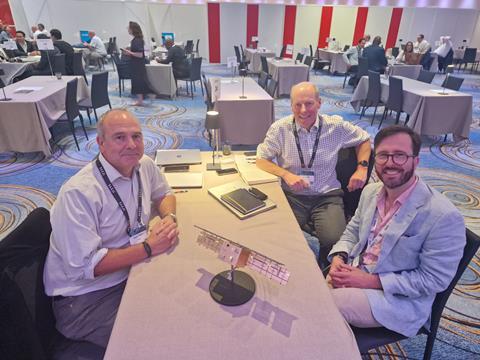
Lathrope (pictured, left of table, meeting at RVS 2025) said the company is now on its fourth generation of satellites, with larger radar arrays improving resolution and scene size, alongside more efficient downlinks.
“That 25-centimetre resolution imaging mode that ICEYE has developed delivers a very high-resolution radar image which enables us to zoom right in on objects on the earth’s surface,” he added.
From flood to multi-peril
Rupert Bidwell, vice president of insurance solutions, said ICEYE has moved from a mono peril offer to a multi-peril proposition over the past two years.
“Last year we talked about the hurricane solution being trialled in during the hurricane season,” he said.
“It was trialled successfully in Helene and Milton, and then we launched it formally in March.
Within 24 hours of hurricane landfall, we produce an output that insurers can use to determine the changes caused by the hurricane, including flood components at block and plot level.”
Bidwell (pictured right of table, behind GR’s David Benyon) said ICEYE launched its earthquake solution early September, built on continuous pre-imaging of Californian fault lines to enable change detection immediately after a significant quake, including fire-following assessment.
“During the Noto earthquake last year in Japan,” he said. “We tested our wildfire tool to determine the fire-following element of the loss as well.”
Flood analytics have also accelerated, Bidwell explained.
“We are now releasing our flood extent data within six to eight hours from the start of the flooding. Previously, we were sharing data 24 hours from the flood peak,” he added.
Scale, reach and speed
Lathrope said more satellites mean richer event coverage across the globe, with tasking that captures strips either side of the orbital track and revisit opportunities multiple times per day.
“You see that expanding network means that we can access pretty much anywhere on the surface of the Earth, multiple times a day,” he said. “Six to 18 times a day, depending on timing.”
Terrain matters for radar imaging, he noted, but constellation density helps work around shadows, with flat flood plains easier than dense urban topography to image.
Beyond product, the client mix is widening.
“We have increased the number of reinsurer clients, and we have also secured more US clients,” Bidwell said.
“We have also developed more interactions with reinsurance brokers, because they want to offer our services to their clients,” he continued.
ICEYE sells one-off event data to prospects but seeks to move mature users onto subscriptions aligned to use cases and value.
The same core products also serve government and banking users, with FEMA in the US and Australia’s National Emergency Management Agency among referenced customers.
Geographic expansion includes Africa, South Africa, Thailand, Taiwan, India, Mexico and Brazil.
Lathrope emphasised the direction of travel remains clear.
“It is about constellation growth providing more capacity, more imagery and greater coverage of events. That enables more revisits and richer data and lets us cover more events globally,” he said.
Bidwell framed the pitch simply.
“What Stephen has described is effectively a multi-peril proposition. That is more compelling to insurers, because they can get more value from our data,” he added.


No comments yet